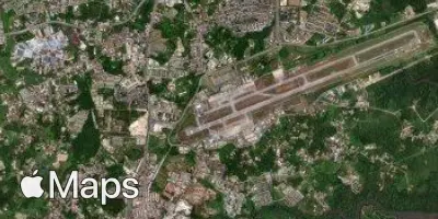
Kuching
KCH
Kuching International Airport

Malaysia
Departures


Kuching International Airport
Kuching International Airport (KCH) serves the city of Kuching, Malaysia, located approximately 7 miles from the city center. The airport sits at an elevation of 89 feet above sea level, a low-lying position typical of coastal and near-coastal airports in the region.
As no route data is available for this airport, its specific traffic patterns and connectivity cannot be characterized here. Travelers using Kuching International Airport should note its modest elevation and close proximity to the city it serves, both of which are relevant to ground transfer times and general airport operations. The low elevation means the airport is unlikely to experience the kind of altitude-related weather variability seen at higher-elevation airports, though local tropical weather conditions in this part of Malaysia can still influence flight operations.
Passengers flying to or from Kuching should plan for a short transfer between the airport and the city given the limited distance separating the two, making it a convenient gateway for those traveling to or from this part of Borneo.
Height above sea level
89 ft
Distance to city
7 miles
Traffic volume
30 flight per day
Satellite